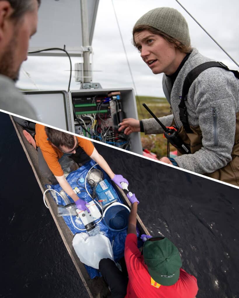
Andrea “Andie” Norton is an ecologist studying the world’s changing rivers. She examines patterns in temperature and nutrients to assess the response of watersheds to climate change, and to build a record of how river environments are changing that could help flag current threats, predict future changes and develop strategies for successful management.
Read more on Science on the Fly
Earth’s rotation slowing down due to melting ice, scientists say
Less ice at the Earth’s poles and more water weight spread around to other places are leading to the planet slowing down.

As the polar ice caps melt, the Earth actually slows down, California scientists say.
Less ice at the Earth’s poles and more water weight spread around to other places are leading to the planet slowing down.
“Human activity has changed the rotation of the Earth,” University of California, San Diego geophysics Professor Duncan Agnew said.
Earth’s rotation has been speeding up slightly for decades, but changes are unfolding.
“That trend slowed, turned around, and is now going in the other direction,” Agnew said. “That’s all because of the effect of global warming.”
We can all agree 2023 was a weird year for weather, right? The United States set a record for the number of billion dollar weather disasters. A major Amazon River tributary reached its lowest water levels in a century during extreme drought. Extreme rain in Libya caused two dams to break, destroying homes and killing over 4,000 people.
And then, of course, there was the heat. 2023 was the hottest year on record. Countries around the world saw heat records fall month after month. The Arctic was hot. The ocean was hot. And debates swirl on about whether we’ve already passed critical warming thresholds.
So how do we put 2023 in context of the greater trend of warming? Here’s what some of Woodwell Climate’s scientists have to say about last year’s record-breaking events.
Did the models predict this?
The dramatic scenes of heat and extreme weather last year prompted many to ask why temperatures had seemingly spiked way above the trend line. Was this unexpected? Was it out of the range of what scientists had modeled? Woodwell Senior Scientist, Dr. Jennifer Francis says not entirely.
“Almost exactly a year ago,” says Francis, “we had just come out of three years of La Niñas and we came close to breaking global temperature records then, even though La Niñas tend to be cooler than neutral or El Niño years. And then along came the strong El Niño of 2023.”
El Niño and La Niña are two extremes of a natural phenomenon that impacts weather patterns across the Pacific, and around the world. In an El Niño year, the prevailing trade winds that normally push warmer waters into the western tropical Pacific—allowing cooler water to well up along the western coast of the Americas—are reversed, resulting in hotter ocean surface temperatures in the eastern equatorial Pacific. When the ocean is hotter than the air above it, that heat is released into the atmosphere, often making El Niño years record breaking ones for global temperatures.
“Last year’s spike looks a lot like the last big El Niño event in 2015-2016. It’s just that now the whole system is warmer. So to me, it wasn’t at all a surprise that we smashed the global temperature record in 2023,” says Francis.
The spike put global temperatures far above the average of climate model simulations, but that doesn’t mean the models didn’t account for it. Risk Program Associate Director, Dr. Zach Zobel, says that averages tend to smooth out natural year-to-year fluctuations, when in fact the upper and lower ranges of model predictions do encompass temperatures like the ones seen in 2023.
“It was well within the margin of error that you would expect for natural variations,” says Zobel.
How does ocean heat impact the climate?
One element of last year’s heat, one that wasn’t necessarily forecasted, was the simultaneous appearance of several ocean heat waves around the globe. The ocean absorbs the vast majority of heat trapped by greenhouse gasses, and that heat can be released under the right conditions. El Niño is one example, but in 2023 it coincided with other not-so-natural marine heat waves across the world.
“In pretty much every single ocean right now there are heat waves happening, which is something quite new,” says Francis.
A couple of dynamics could be driving this. One possibility is that, after three years of La Niñas, in which equatorial Pacific ocean temperatures were generally cooler than the air, the ocean simply absorbed a lot of heat, which was then primed to be released in an El Niño year. Another, Zobel suggests, could be recent shipping laws that required shipping vessels to eliminate sulfate emissions by 2023. Sulfates are a pollutant that may have been helping bounce back solar radiation, hiding the true extent of warming.
“Usually when there’s an El Niño, the eastern tropical Pacific is very warm, but it doesn’t actually drive up ocean temperatures everywhere,” says Zobel. “That was the biggest surprise to me: how warm the northern hemisphere of the Atlantic and Pacific were for most of last year and into 2024.”
Ocean heat waves are typically long-lived phenomena, lasting many months, and so can be a useful tool for meteorologists looking to predict 2024’s extreme weather events.
“The good news is that it provides some kind of long-term predictability about weather patterns in the upcoming year,” says Francis. “The bad news is that they tend to be unusual weather patterns, because those ocean heat waves aren’t usually there.”
Will next year be hotter?
So are we in for another, hotter year after this one? Risk Program Director Dr. Christopher Schwalm says it’s likely.
“Warming predictions for 2024 from leading scientists all forecast a higher level of warming this year than last year,” says Schwalm.
Already, March 2024, was the 10th month in a row to break temperature records. Zobel says it’s typical for the year following an El Niño peak to maintain high temperatures.
“Because the ocean spent a good amount of the year last year warmer than average, that energy is typically dispersed throughout the globe in the following year,” says Zobel. “So even though the tropical Pacific might return to normal, that energy is still in the system.”
However, atmospheric scientists are already seeing signs that El Niño is slowing down and flipping to its counterpart, La Niña, adding another layer of complexity to predictions for 2024.
“The 2024 hurricane season is a large concern,” says Zobel. “La Niña is a lot more conducive to tropical cyclone development. If we combine above average numbers with the amount of energy that storms have to feed on, it’ll be a shock to the system.”
What does this mean for 1.5?
In the discussions around 2023’s temperatures, one number dominates the conversation: 1.5 degrees C. This is the amount of warming countries around the world agreed to try to avoid surpassing, in accordance with the United Nations’ 2015 Paris Climate Agreement. Estimates from Berkeley Earth say that 2023 may have been the first year spent above that threshold.
This assertion may take several years to verify— one year spent physically above 1.5 degrees of warming does not indicate the UN threshold has been permanently passed. What scientists are looking for is a clear average trend line rising above 1.5 degrees C without coming back down, and for that you need several years of data. That, regrettably, creates a lag time between climate impacts and updating climate policy. But, for many, the debate around the arbitrary 1.5 degree goal has become a distraction. Schwalm says scientists and policy-makers should be focusing on urgently combating climate change whatever the numbers say.
“We are already living in a post-Paris Agreement reality,” says Schwalm. “The sooner we admit that and reimagine climate policy, the better.”
“Actual real world impacts are going to be there, whether we’re at 1.48 or 1.52,” says Zobel.
And Francis agrees. “There are so many indicators telling us that big changes are underfoot, that we are experiencing major climate change, but reaching 1.5 isn’t going to all of a sudden make those things worse. It’s just one more reminder we’re still on the wrong track and we’d better hurry up and do something.”
Why no one knows exactly how much old-growth forest we have left

To use older trees to fight climate change, we need to know where they are. But new maps created by the Forest Service aren’t that detailed
This statement, say critics, is especially true of the maps created by the U.S. Forest Service to inventory the nation’s largest carbon sinks: its mature and old-growth forests.
In April 2023, under pressure from the Biden administration, the Forest Service completed its first-ever nationwide inventory of mature and old-growth forests found on federal lands.
This inventory of older trees is part of an ambitious Biden administration plan to harness the power of our nation’s forests as a nature-based solution to the climate crisis.
Read more on Columbia Insight.
When it comes to reversing climate change, trees are a big deal. Globally, forests absorb nearly 16 billion metric tonnes of carbon dioxide per year, and currently hold 861 gigatonnes of carbon in their branches, leaves, roots, and soils. This makes them a valuable global carbon sink, and makes preserving and maintaining healthy forests a vital strategy in combating climate change.
But not every forest absorbs and stores carbon in the same way, and the threats facing each are complex. A nuanced understanding of how carbon moves through forest ecosystems helps us build better strategies to protect them. Here’s how the world’s different forests help keep the world cool, and how we can help keep them standing.
Tropical forest carbon
Tropical rainforests are models of forest productivity. Trees use carbon in the process of photosynthesis, integrating it into their trunks, branches, leaves, and roots. When part or all of a tree dies and falls to the ground, it is consumed by microorganisms and carbon is released in the process of decay. In the heat and humidity of the tropics, vegetation grows so rapidly that decaying organic matter is almost immediately re-incorporated into new growth. Nearly all the carbon stored in tropical forests exists within the plants growing aboveground.
Studies estimate that tropical forests alone are responsible for holding back more than 1 degree C of atmospheric warming. 75% of that is due simply to the amount of carbon they store. The other 25% comes from the cooling effects of shading, pumping water into the atmosphere and creating clouds, and disrupting airflow.
In many tropical forest regions, there is a tension between forests and agricultural expansion. In the Amazon rainforest, land grabbing for commodity uses like cattle ranching or soy farming has advanced deforestation. Increasing protected forest areas and strengthening the rights of Indigenous communities to manage their own territories has proven effective at reducing deforestation and its associated emissions in Brazil. “Undesignated lands” have the highest levels of land grabbing and deforestation.
Fire has also become a growing threat to the Amazon in recent years, used as a tool to clear land by people illegally deforesting. When rainforests have been fragmented and degraded, their edges become drier and more susceptible to out-of-control burning, which weakens the forest even further. Enforcing and strengthening existing anti-deforestation laws are crucial to reduce carbon losses.
In Africa’s Congo rainforest, clearing is usually for small subsistence farms which, in aggregate, have a large effect on forest loss and degradation. Mobilizing finance to scale up agricultural intensification efforts and rural enterprise within communities, while implementing protection measures, can help decrease the rate of forest destruction. Forests and other intact natural landscapes such as wetlands and peatlands could be the focus of climate finance mechanisms that encourage sustainable landscape management initiatives.
Temperate forest carbon
Much of the forest carbon in the temperate zone is stored in the trees as well— particularly in areas where high rainfall supports the growth of dense forests that are resilient against disturbances like drought or disease. The temperate rainforests of the Northwestern United States, Chile, Australia, and New Zealand contain some of the largest and oldest trees in the world.
Two thirds of the total carbon sink in temperate forests can be attributed to the annual increase in “live biomass”, or the yearly growth of living trees within the forest. This makes the protection of mature and old-growth temperate forests paramount, since older forests add more carbon per year than younger ones and have much larger carbon stocks. Timber harvesting represents one of the most significant risks to the carbon stocks in temperate forests, particularly in the United States where 76% of mature and old growth forests go unprotected from logging. Fire and insects are also significant threats to temperate forests particularly in areas of low rainfall or periodic drought.
Maintaining the temperate forest sink means reducing the area of logging, by both removing the incentive to manage public forests for economic uses and by providing private forest owners with incentives to protect their land. Low-impact harvesting practices and better recycling of wood products can also help bring down carbon losses from temperate forests. In areas threatened by increasingly severe wildfires, reducing fuel loads especially near settlements can help protect lives and property.
Boreal forest carbon
In boreal forests, the real wealth of carbon is below the ground. In colder climates, the processes of decay that result in emissions tend to lag behind the process of photosynthesis which locks away carbon in organic matter. Over millennia, that imbalance has slowly built up a massive carbon pool in boreal soils. Decay is even further slowed in areas of permafrost, where the ground stays frozen nearly year round. It estimated that 80 to 90% of all carbon in boreal forests is stored belowground. The aboveground forest helps to protect belowground carbon from warming, thaw, decay, and erosion.
Wildfire— although a natural element in boreal forests— represents one of the greatest threats to boreal forest carbon. With increased temperatures, rising more than twice as fast in boreal forests compared to lower latitudes, and more frequent and long-lasting droughts, boreal forests are now experiencing more frequent and intense wildfires. The hotter and more often a stand of boreal forest catches fire, the deeper into the soil carbon pool the fire will burn, sending centuries-old carbon up in smoke in an instant. Logging of high-carbon primary forests is also a big issue in the boreal.
The number one protection for boreal forest carbon is reducing fossil fuel emissions. Only reversing climate change will bring boreal fires back to the historical levels these forests evolved with. In the meantime, active fire management in boreal forests offers a cost effective strategy to reduce emissions— studies found it could cost less than 13 dollars per ton of carbon dioxide emissions avoided. Strategies for fire management included both putting out fires that threaten large emissions, and controlled and cultural burning outside of the fire season to reduce the flammability of the landscape.
Science on the Fly harnesses fly fishing community to protect rivers
How scientists and anglers are helping to tell the world’s climate change story.
Fly fishers are full of good ideas. Just ask them. They don’t always amount to anything, but, in the confines of a fly shop or between the gunnels of a drift boat, the ideas pour forth.
But one good idea, launched during a southwest Colorado environmental symposium a few years back, has taken root. And this past summer, it sprouted some important international branches that will hopefully help climate scientists better understand how the world’s existential climate crisis is impacting our rivers.
At the conference in Telluride in 2019, Dr. Max Holmes, president and CEO of the Woodwell Climate Research Center (WCRC) in Falmouth, Massachusetts, met John Land Le Coq, the founder and CEO of Fishpond, where the two discussed the idea of monitoring rivers over time for their chemical composition, with the intent of determining how climate change affects that composition. But, they discussed, the monitoring needed to be consistent and lasting in order for Holmes and his team at WCRC to glean truly meaningful data.
Continue reading on Fly Fisherman.
Broken record: March is 10th straight month to be hottest on record, scientists say
For the 10th consecutive month, Earth in March set a new monthly record for global heat — with both air temperatures and the world’s oceans hitting an all-time high for the month, the European Union climate agency Copernicus said.
March 2024 averaged 14.14 degrees Celsius (57.9 degrees Fahrenheit), exceeding the previous record from 2016 by a tenth of a degree, according to Copernicus data. And it was 1.68 degrees C (3 degrees F) warmer than in the late 1800s, the base used for temperatures before the burning of fossil fuels began growing rapidly.
Since last June, the globe has broken heat records each month, with marine heat waves across large areas of the globe’s oceans contributing.
Read more on Associated Press News.