Offsetting carbon alone won’t hold water
As I look out over the river from a floating cabin at the Mamirauá Sustainable Development Reserve in central Amazonia, it’s hard to imagine that water could become an issue here. It is the end of the rainy season and river levels, as usual, have peaked at 9-12 meters above their dry season mean. To my delight, we took canoes for a “hike” on the forest trails and spotted large fish like tambaqui and pirarucu , temporarily released from the confines of the riverbanks. The riverside communities we visit are practiced in dealing with these large seasonal fluctuations, having built their houses on stilts high on the riverbank and using boats to negotiate the ebbs and flows of the river, which they rely on for their livelihoods and transportation.
Climate change was the center of the debate between rural producers, scientists, public authorities and indigenous peoples at the Symposium to Celebrate the 20th anniversary of the Tanguro Research Station, which took place in Brasilia from June 10 to 12. The event highlighted the dialogue between the groups as a key to socio-environmental and economic transformation in favor of a possible future for life on Earth.
Functioning as an open-air laboratory, the Tanguro Research Station is located in the city of Querência, in Mato Grosso, in the southeastern Amazon. It was founded by IPAM (Amazon Environmental Research Institute) in partnership with the company Amaggi and the Woodwell Climate Research Center in the United States. In two decades of existence, the results of this joint initiative add up to more than 180 high-impact scientific publications and bring together researchers from seven countries studying the environment and agriculture.
Ângela Conceição, president of FETAGRI, speaks on a panel at the event (Photo: Lucas Guaraldo/IPAM)
‘’The revolution in the countryside cost almost 50% of the Cerrado and 20% of the Amazon, this model is no longer sustainable, “said André Guimarães, executive director of IPAM. “It is necessary to ask questions to companies, as they will also have to adapt services to a new climatic condition,” he added. The director recalled that the assumption of the work at the Tanguro Research Station is to bring agricultural production closer to nature conservation.
The plurality of experiences and knowledge shared at the symposium was highlighted by Max Holmes, CEO of the Woodwell Climate Research Center, an institution that has been working alongside IPAM for thirty years.
“Bringing together this group of experts from science, civil society and from different places gives me hope and optimism. The challenge for all of us is to take forward the big ideas around the climate solutions discussed. Climate conferences are opportunities to continue to make progress on these incredibly urgent issues, which can only be solved in partnership,” Holmes said.
Balance
The meeting of different sectors around the socio-environmental and economic discussion comes at a time when studies show the loss of natural functions of tropical forests due to the global burning of fossil fuels, and, in Brazil, mainly due to deforestation, degradation and fire.
Ecosystem services, as the benefits produced by nature are called, maintain all forms of life, ensuring air quality and the availability of water and food, for example. They contribute to pollination, pest control and local climate regulation, providing adequate rain, humidity and temperature for agricultural production.
“How do we build a land use solution so that people understand that it is possible to reconcile forest with conservation, development with job and income generation from a better use of what we have already cut down? This is Brazil’s challenge. That is why we have sought a partnership with IPAM. That is why we created, in the State of Pará, the State Policy on Climate Change and the Amazon Now program,” said Helder Barbalho, governor of the State of Pará, present at the event.
Pará Governor HelderBarbalho and Minister Paulo Teixeira participated in the symposium (Photo: Disclosure/Agência Pará)
“We don’t know what the world will be like going forward, we just know it can’t be the same. We have a lot to learn and build with each other. Climate change is real and the producer realizes it, but if he does not feel he belongs in the conversation about what needs to be improved, it is difficult to engage,” said Juliana Lopes, director of ESG, Communication and Compliance at AMAGGI.
From 2022 to 2023, agriculture grew by 15.1%, influencing GDP performance, but still putting pressure on Brazilian biomes. The Tanguro Research Station develops studies to understand the influence of the forest on agriculture and vice versa, in order to subsidize environmentally and socially sustainable production and conservation strategies.
“Results of Tanguro’s research socialized with us are important to see new perspectives and develop agriculture, ensuring food security,” added ÂngelaConceição, president of FETAGRI (Federation of Agricultural Workers of the State of Pará).
Juliana Lopes endorsed the recognition: “The partnership with IPAM was the way that AMAGGI found, with researchers, to make an assessment of how we can ensure continuity in agricultural production, investing in the conservation of biodiversity and native areas.”
Knowledge generation
Storing half the carbon emitted on the globe, tropical forests provide climate stability. This stockpile capacity is being hampered by climate change caused by human activities. “Our challenge is to find ways to maintain that service and, at the same time, growth and prosperity,” said Woodwell Climate Research Center researcher Michael Coe.
And how to find an answer to this challenge? The solution may lie in nature itself. Data presented by Wayne Walker, senior scientist at Woodwell, shows that nature-based solutions have the potential to deliver 37% of the emissions reduction needed to limit global average temperature rise to less than 2°C. “Land is more than just a carbon store. We need to implement these solutions in a scalable way, ensuring capital flows with equity and sustainability,” he commented.
IPAM researcher Filipe Arruda pointed out that environmental disturbances have been occurring more intensely with climate change. “The impact on the habitat modifies the animal and plant species on site, changing everything from temperature control to pest control within the forest and in agricultural areas.”
Leonardo Maracahipes, coordinator of the Tanguro Research Station and researcher at IPAM, presented a study on the change in tree leaves in areas of intact forest and in those fragmented by agricultural activity. “The thickness of the leaf was greater in the area of agriculture, while the size of the leaf was greater in the areas of preserved forest,” he explained, demonstrating vegetation strategies to adapt to the surroundings.
In farming, the effects of nature are also the object of study: “We estimate a 6% reduction in soybean yield for every 1°C increase in temperature,” said Ludmila Rattis, a researcher at IPAM and the Woodwell Climate Research Center. On the positive side, when the forest is maintained, it helps in production. Bianca Rebelatto, a researcher at IPAM, recalled that 90% of Brazil’s agriculture is not irrigated and that forests protect crops against heat waves and reduce future climate challenges.
Scientists working at the Tanguro Research Station (Photo: Mitch Korolev/Woodwell)
Responses presented by the sectors to avoid more extreme events, reducing damage to the environment and promoting responsible ways of living include, in addition to sustainable production, the bioeconomy of natural products from the Amazon and Cerrado.
“Land use change and climate change have already increased the chances of a catastrophic fire in the Xingu by another 10%,” explained Paulo Brando, IPAM associate researcher and professor at Yale University in the United States. “About 16% of forests in the southeastern Amazon may burn due to these factors. Fire-degraded forests seem healthy from the point of view of remote sensing, but they are much more vulnerable to extreme events such as drought, which is what is happening in the Xingu and much of the region.”
According to Brando, the Xingu region is 2°C warmer due to increased deforestation and human pressure on the natural landscape. The Xingu Indigenous Territory functions as a local air conditioner, with 5°C less than monocultures and neighboring pastures, revealed a technical note produced by IPAM and the Woodwell Climate Research Center.
While the situation is not resolved, the peoples of the Xingu continue to struggle to produce. “We have the land, but we keep buying in the city. We, from the Xingu, are still studying how we can make production on a larger scale, “said Yuri Kuikuro, a master’s student in Ecology at INPA (National Institute for Amazonian Research). “It is necessary to bring young people to train, to use technology, to try to understand how to produce to maintain our culture. Add science to figure it out,” he concluded.
Survival
“First we have to think about surviving climate change: working in the collective, regardless of whether it is civil society, company or public power, for our physical and mental survival,” said Mauro O’ de Almeida, Secretary of State for Environment and Sustainability of Pará, present at the symposium.
The climate emergency alerts to the Amazon’s point of no return, also known as the tipping point, from which the biome would lose its natural capabilities and become a type of degraded ecosystem — a “zombie Amazon”. In the Cerrado, the reality also worries scientists, given that most of the biome’s remaining native vegetation is within private rural properties.
“It is common to hear that the world will end, but it has already ended, due to climate change, for the people who died in Rio Grande do Sul,” said researcher Ludmila Rattis, referring to the extreme climatic event of rainfall in Rio Grande do Sul this year. About 175 people died and 38 are missing. More than 2 million were affected by the floods, according to the Civil Defense.
In the Amazon, the Rio Negro drought in 2023 affected all 62 cities in the State of Amazonas and affected more than 600,000 people, also according to the state Civil Defense.
“The Xingu Indigenous Territory is also being impacted by climate change. Indigenous people have been talking about this for a long time and we are not taken seriously. These extreme events are affecting all sectors, so sitting at the table with partners who were once our enemies shows how we need to be united to change the scenario we have, “said Kaianaku Kamaiurá, partnership coordinator at OURS and coordinator of the Amazônia de Pé project.
The climate commitments of Brazil and the world, to be renewed and expanded until COP30 (United Nations Conference on Climate Change) in Belém, are the necessary measure to prevent the worsening of housing conditions on the planet and prevent more lives from being lost.
“First, that the world can accelerate the change in the energy matrix to stop emitting carbon dioxide. Second, pay for the maintenance of the forest and its recovery. In the past, I remember that agribusiness was against the climate debate, but not today: it has assumed an awareness that it needs the forest. COP30 will be the great political space in the Amazon to demand from the world attention for those who are preserving,” said Paulo Teixeira, Minister of Agrarian Development and Family Agriculture.
The Tanguro Research Station 20-Year Celebration Symposium was held by IPAM in partnership with the Woodwell Climate Research Center, Yale University School of the Environment, and Max-Planck-Geselschaft. Learn more about the Tanguro Research Station and how to donate on the website.
Hurricane Beryl may be a stark preview of what’s to come
The monster storm is a history-maker, fueled by extremely high ocean heat and proving the Atlantic season is off to an extremely active start
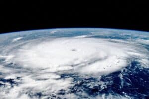
Hurricane Beryl’s rapid evolution from a tropical depression to a major Category 5 threat so early in the summer is raising alarms that forecasts for a “hyperactive” Atlantic storm season might be on target.
Late Monday, the churning Beryl escalated to Category 5 intensity, packing maximum sustained winds of 165 miles per hour — unprecedented this early in the Atlantic season, according to the National Hurricane Center. It became the strongest July Atlantic hurricane on record, surpassing the 160-mile-per-hour maximum winds set by Hurricane Emily in 2005. Before Emily, Hurricane Allen in August 1980 held the record for the earliest Atlantic hurricane clocking 165-mile-per-hour winds.
Read more on The Boston Globe.
The exhibit “In Flux: Perspectives on Arctic Change” sprawls across two floors of one of Cape Cod’s oldest summer-home mansions— Highfield Hall.
When they first walk in, visitors see two of Woodwell Climate Board Member Georgia Nassikas’ encaustic paintings flanking a banner with the name of the exhibit. Woodwell Senior Geospatial Analyst Greg Fiske’s maps light up the entry hall. Sounds from Michaela Grill and Karl Lemiuex’s documentary film cascade down from the staircase to the second floor. Tall windows illuminate Gabrielle Russomagno’s small, detailed photographs of the Arctic’s durable vegetation and Aaron Dysart’s reflective sculpture, which invites us to tread with caution.
These six artists’ works have been on display in Highfield Hall since May 21st, and will remain as part of the “In Flux” exhibit until July 14th. On July 11th, some of the artists will participate in a panel discussion with their Woodwell scientist collaborators, Dr. Jennifer Watts and Dr. Sue Natali.
Connecting to a new perspective
The exhibit’s goal is to connect a distant community to the reality of Arctic change. Many of us may never have the opportunity to visit the Arctic, or study it like Woodwell Climate researchers do. Art can help communicate the reality of an unfamiliar place.
Woodwell Climate’s Arctic research informed every piece of art on display at Highfield Hall. Each artist has had the chance to travel to the Arctic alongside Woodwell researchers Dr. Jenny Watts and Dr. Sue Natali. According to Watts, traveling with an artist brought a new perspective to a landscape she had visited so many times before.
“They are looking through the lens of the artist,” Watts says, “They’re kind of seeing it through this fresh look, and then we’re able to see it through their eyes.”
Russomagno calls herself a “student of the Arctic.” Like some of the other artists, she had never been so far north before her 5-day trip with Watts to Alaska. She recalled the whirlwind experience of creating while acclimating to her new surroundings.
“I was able to be making art while discovering,” Russomagno says, “I was looking at the same material [as Watts] and understanding it completely differently.”
The exhibit assumes visitors might come in with certain assumptions about the Arctic, but hopes they will soon throw their preconceived ideas out of Highfield Hall’s many windows. One of these false ideas, Watts says, is that the Arctic is a barren wasteland.
“In the summer especially, it’s brimming with life, and we wanted to show that part of the story because it’s often overlooked,” she says.
Bursts of life from the summer tundra— small shrubs, mosses, lichens, and grasses— are featured in Russomagno’s series of photographs in “The Quiet & the Mighty.” Nassikas’ encaustic paintings uniquely depict color, horizon, and change. Fiske’s maps teleport us from Highfield Hall to the tundra. The entire “In Flux” exhibit displays unexpected dimension.
Why combine art and science?
The experience of the art at Highfield places the viewer in the atmosphere of the Arctic tundra. A quiet place with unexpected vibrancy, the uptick in frequency of deafening crashes as ice melts, breaks, and shifts. These elements would be much harder to glean from traditional methods of communication in the science world. A graph, for example, would likely not evoke such a strong emotional response.
“I think Woodwell and other science organizations struggle with conveying their data, and hard facts, and things they’re discovering to a general audience,” Nassikas says, “Art is another way to change the world for the better.”
Dysart echoed this message: “If research does not connect with people and culture, nothing’s going to change. Art can make that connection. Art has strength that words don’t.”
Our shared home
Part of the power of this exhibit is its setting. We have the opportunity to experience the Arctic’s dynamic changes outside of its natural barriers, and Highfield Hall is the tether.
Dysart says it is “A call back to [our] normal life as opposed to the gallery aesthetic.”
Highfield is a home. It may not feel familiar to everyone, with its extravagant furnishings, stained glass windows, chandeliers, and many rooms, but it was built by humans, for humans. The house has withstood the test of time, though it has changed greatly since its construction in 1878. The Arctic, too is a home for many people, animals, and plants— one that is threatened by climate change. The exhibit at Highfield Hall brings the changing Arctic home to our own changing landscape.
New water quality technology makes its debut in Buzzards Bay
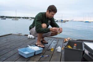
Baywatcher sampling titrating dissolved oxygen
Every five days, Lisa Kingston, a 62-year-old critical care nurse, drives to the Onset pier to collect samples in the murky waters of Buzzards Bay.
“This is our oxygen bottle and this is our salinity bottle. We pull this — bloop, bloop, bloop, bloop, bloop —” she says, imitating the sound of water, “and that fills up.”
At the end of this dock, Kingston performs an hour-and-a-half-long data collection routine — just as she has done 22 times a summer for the past two years. She and fellow volunteer Susan Scott are here to take measurements on oxygen, water temperature, salinity, and more. Scott, a 77-year-old retired arts administrator, rips open a reagent packet and adds it to a glass vial.
2024 Switzer Fellowships awarded to environmental change-makers
Twenty environmental leaders have been chosen as 2024 recipients of the Switzer Environmental Fellowship, a program of the Robert and Patricia Switzer Foundation that awards graduate students a $17,000 cash award and leadership training to support their education and career development at 12 universities in New England and California. The 20 fellowships total $340,000 in awards.
During their fellowship year, Switzer Fellows cultivate their personal leadership skills toward advancing social equity, build relationships, and expand their networks through shared learning and professional development activities. Switzer Fellows receive support throughout their careers to pursue interdisciplinary and collaborative work, positioning them for leadership in the nonprofit, government, philanthropic, private, and academic sectors. The competitive fellowships are awarded based on leadership potential and commitment to environmental problem-solving. Switzer Fellows demonstrate innovation and collaboration, as well as commitment to advance social equity as a fundamental part of their environmental work. The 2024 Switzer Fellows join a network of over 750 Switzer Fellows working across the United States and around the world.
“The Switzer Foundation believes that talented and committed individuals can make change in the world, and we invest in supporting their continued leadership and professional development,” says Executive Director, Sarah Reed. “As lifelong members of the Switzer Network, the new fellows will be able to increase their impact as environmental leaders through shared learning, collaboration, and mutual support. We are thrilled to welcome these environmental and social change-makers to our community as 2024 Switzer Fellows.”
Robert and Patricia Switzer established the foundation with a belief in the power of individuals to make positive change in the world, and to support and encourage people dedicated to solving applied environmental problems. The 2024 Switzer Fellows come from diverse social, academic, and economic backgrounds and bring an impressive breadth of expertise on topics including agriculture, agroecology, avian ecology, environmental justice, environmental policy, environmental remediation, food systems & access, forestry, holistic land management, housing decarbonization, public health, renewable energy, tribal sovereignty, and urban planning. More information about the 2024 Switzer Fellows, and links to their profiles, is available on the Founation website.
The Robert and Patricia Switzer Foundation identifies and nurtures environmental leaders to create positive environmental change. The foundation awards academic fellowships and project grants, sponsors professional development activities, and fosters a vibrant network of more than 700 Switzer Fellows who are environmental and social change leaders working across academia, non-profits, government, philanthropy, and the private sector. For more information, see their website.
I am a woman that lives for adventure, mud, and heat. The Caribbean sunshine, warmth, and humidity of my island, Boriké, hug me every single day. That’s why many people find it strange that in the summer of 2022 I ended up on the other side of the world from my Carribean Island home, willingly experiencing freezing temperatures.
So, here’s my story: I grew up in Puerto Rico, a couple of Caribbean islands that are very vulnerable to the effects of climate change. The burning of fossil fuels and the destruction of forests are causing Arctic ice to melt which, in addition to affecting the climate of the planet, is affecting Boriké. Rising sea levels, more frequent and stronger hurricanes, and constant landslides are some of the dangers I am already experiencing on my island.
Although I do a lot of environmental work there, a few years ago I decided to visit the Arctic to fully understand how climate change is also affecting other types of ecosystems. Because climate change is a global phenomenon, I sought to learn how to properly support and collaborate with other at-risk communities outside of the boundaries of my islands, even if that meant stepping outside my comfort zone in another part of the world.
The problem was: I’ve never lived in polar temperatures. I’ve hiked hundreds of miles of coastal and humid tropical forests to conduct research, yet visualizing myself as an Arctic scientist in an environment so different was nearly impossible.
But as I said before, I am a woman that lives for adventure, so if I was going to experience a new environment I was going to get the full experience.
So that summer I packed up my giant backpack and joined eight other young researchers for Woodwell Climate’s Polaris Project— a two-week long research trip in the Yukon Kuskokwim Delta of Alaska. Polaris gives students the chance to design their own studies and gain experience conducting Arctic research. It was with Polaris that my battle against the cold began.
I spent my time in remote areas of the Tundra, a carbon-rich ecosystem lacking mountains and trees, yet full of life and history. I had to live in a tent to conduct my research on how the groundwater system is changing. My usual day in the Arctic looked like lots of hiking in the mud, carrying pipes and drills in my backpack, wearing mosquito nets, and taking water and soil samples in temperatures as low as 48 degrees Fahrenheit. Although 48 degrees might not be cold for many folks on Turtle Island— the original name for North America — as someone from the Caribbean, anything below 70 degrees is already too cold to handle.
Add onto that, the rainy days, the lack of access to communications, internet, electricity, and water service. Needless to say, my first experience with cold was an intense one.
But you know what? I loved it.
I loved working with new friends, colleagues, and mentors. I loved getting to know the Yup’ik and Cup’ik communities guarding these lands. I loved doing science projects that served a common good.
I loved fieldwork in the cold.
However, when I went back home and felt that rich Caribbean sunshine and heat again, I began questioning myself.
How could I have enjoyed working in the cold? Could I really be a scientist in the Arctic even though I didn’t grow up in the Arctic? My Polaris experience lasted only two weeks, and they were the most challenging two weeks of my entire career. Could I endure weeks, months, or even years in these conditions?
Would I let the cold win this battle?
Well, I would have to face the cold one more time either way. Polaris students present the results of their research each year at the American Geophysical Union conference in December. To give my research presentation, I had to travel to Chicago— in the middle of winter.
Have you ever felt the chilling winds of Chicago? It’s known as the windy city for crying out loud! I guess it was time for me to get back to the battlefield.
I packed all my coats, got on a plane, touched down in traditional Potawatomi lands, and tried not to freeze to death.
The wind and snow was strong the day I had to present my research. It was actually my first time experiencing snow falling from the sky, so I bundled up warmly. But as I was walking to the convention center, going over in my mind the speech I had to give, I felt the most chilling cold I had ever experienced in my life. When I looked down at my feet, I realized that I had packed the wrong shoes! In thin flats, my feet were totally exposed.
This was the moment you might conclude that the cold finally beat me. Yet, when I looked back down at my exposed feet, I just couldn’t stop laughing.
After so much effort to “win the battle”, at that very moment I realized the battle doesn’t exist. There is no battle against the cold.
Living in the cold is a lifestyle like any other. Just as my ancestors taught me how to live in harmony with the tropical climate, there are entire communities that apply their millennia-old knowledge to live in harmony with polar temperatures, and in fact depend on it to keep the ground they are built on from thawing and collapsing.
It wasn’t until that moment in Potawatomi lands that I fully realized how much I loved working in Yupi’k and Cupi’k lands. I learned that, whether it’s in the Arctic or in the Caribbean, to become a responsible scientist I need to rethink and rework my perspective and relationship with the land.
Valuing and protecting cold lands, using guidance from the communities that live there, is critical to maintaining a stable climate. For me, embracing the cold gave me a strong step towards stopping climate change.
The MacGyver session at the annual American Geophysical Union (AGU) conference is full to the brim with scientists showing off blinking circuit boards and 3D-printed mechanisms. Research Assistant, Zoë Dietrich, stands in front of her poster and a plexiglass cube sprouting wires. As she speaks, a whizzing sound emanates from the box as it lifts itself up on one side, holding itself open long enough to flush the interior with air from the room. A laptop screen reads out numbers from the sensors in the box, detailing changes in the concentrations of carbon dioxide and methane within.
Dietrich constructed this device herself. It’s a low-cost, autonomous, solar-powered chamber designed to float on water and measure the flow of carbon into and out of the water. Dietrich has spent the past 1.5 years testing and troubleshooting various prototypes, and has already begun deploying models at research sites in Brazil and Alaska. Now she’s sharing her work with the broader scientific community in hopes of encouraging others to build their own versions.
“One of the goals of the chamber project is to make the construction very accessible so that scientists like me, without formal engineering training or background, can build the chambers pretty easily,” says Dietrich.
This was good news for Grand Valley University masters student, Jillian Greene, and her professor Dr. Sean Woznicki, who encountered Dietrich and her chambers at AGU. Though neither of them had experience with mechanical or electrical engineering, they knew immediately a device like Dietrich’s could be invaluable to their research.
Greene’s project involves sampling carbon emissions at drowned river mouth estuaries connected to Lake Michigan. She and Woznicki will then correlate that data with other ecological characteristics gleaned from satellite imagery. There are over one hundred of these freshwater estuary-like features around the region, and Greene and Woznicki are hoping to paint a complete picture of their cumulative role in carbon cycling.
“Originally, I was going to manually sample and quantify with a gas chromatograph,” Greene says. That’s a time-consuming process that limits the amount of data one team can collect. With the chambers, however, Greene can collect emissions data every 30 seconds—greatly expanding the amount of data she’ll be able to incorporate into her models.
“This is going to make our model a lot more robust and hopefully applicable to other drowned river mouth estuaries in the region,” says Greene.
Greene and her research team have already created and deployed 6 chambers. Since AGU, she has been in contact with Dietrich, troubleshooting issues as they arise and learning an entirely new set of skills as she goes.
“[the team] has learned how to solder, how to interpret the circuit diagrams, problem solve, and adjust for our kind of unique systems that we’re looking at,” says Woznicki. “It’s really been exciting to use Zoë’s design as a learning experience for masters and undergrad students.”
Dietrich has had other groups at Colgate University and the University of California, Berkeley reach out to her as well, and she is planning to publish a paper this fall that will include detailed instructions for anyone else to construct their own chambers. She’s already shared preliminary drafts of the step-by-step instructions, including photos, diagrams, and tips, as well as programming and data-processing code and a specific materials list with the other research groups. In turn, they have provided her with helpful revisions and ideas for new modifications. Dietrich is excited about the prospect of the designs being implemented by more people. More chambers means more data, which benefits the entire scientific community.
“Our sampling of carbon right now is limited by expensive instruments and where people can go and who has access to these resources,” says Dietrich. “But the goal of this project is to be low cost and more accessible to a broader set of researchers. The chambers are autonomous, and so are accessible to places and times that aren’t otherwise being sampled right now. And taking that a step further, we need to make them accessible to be built by anyone.”