Sobering news for the North
Science columnist Torah Kachur says new research indicates the Canadian North is not as effective a carbon sink as once thought.
One of President Trump’s first actions this past week—and also in his first term—was to announce the withdrawal of the United States from the Paris Agreement. It is a step that is both misinformed and misguided. But how much difference will it make? Here’s what you need to know.
1. Significance of the Paris Agreement
The Paris Agreement was adopted by 197 countries in December 2015 and has been the underpinning of international climate action for nearly a decade. The goals and strategies it sets out are critically important to maintaining a stable climate, which is the foundation of successful societies and economies. The Parties to the Paris Agreement are legally obliged to submit national climate plans, known as Nationally Determined Contributions (NDCs) every five years. However, the content and level of ambition of those NDCs are (as the framing “nationally determined” makes clear) up to the Party itself.
2. Immediate legal implications
The Paris Agreement stipulates that any nation’s withdrawal takes effect one year after an official notice has been submitted to the Secretary-General of the United Nations. In the case of the United States, the earliest effective date of official withdrawal is, therefore, sometime in January 2026. After that, the country will not be bound by its obligations under the Paris Agreement. Those include the submission of NDCs every five years, accounting of progress toward commitments, the submission of biennial transparency reports, and the general obligation to provide climate finance. The United States will also lose, in particular, its right to vote on decisions within the governing body of the Paris Agreement, to nominate members to institutions serving the Paris Agreement, and to participate in emission trading under the Paris Agreement. However, as the United States submitted a new NDC and a biennial transparency report in December 2024, it is currently in compliance with the key obligations under the Paris Agreement.
3. What withdrawal from the Paris Agreement doesn’t do
The executive order of January 21, 2025 does not withdraw the US from the UN Framework Convention on Climate Change (UNFCCC), the 1992 treaty that established the international climate negotiation process. The language of the executive order indicates that this is deliberate—the US will retain its right to vote in the Conference of Parties, as well as its reporting obligations under the UNFCCC. This is possibly due to the fact that a withdrawal from the UNFCCC, a treaty ratified by the U.S. Senate in 1992, requires a two-thirds majority in the Senate. It is also notable that no action has been taken to withdraw the NDC submitted by the Biden Administration in December 2024.
4. The policy impact
The United States’ withdrawal makes maintaining—let alone enhancing—the ambition of emission reduction efforts across the world significantly more difficult. When a major emitter “free-rides,” it de-motivates ambition by others. However, although the U.S. has the second-highest GHG emissions in the world, and has always been a key player in global climate collaboration, it is important to bear in mind that 194 other countries representing approximately 90% of global emissions have not withdrawn from the Paris Agreement.
The executive order is targeted at stopping any U.S. climate finance contributions. This will mean that the new global climate finance goal of $1.3 trillion per year by 2030, agreed upon in Baku, has become much harder to achieve. This will impact the poorest countries directly, as well as degrading the international community’s trust in the effectiveness of the process.
5. What happened last time
President Trump also withdrew the U.S. from the Paris Agreement during his first administration. Then, as now, one of the primary impacts was to create a leadership vacuum. In that case, that vacuum was largely filled by other nations, plus state, local, and business leaders. The resulting groundswell generated momentum that carried into the Biden Administration and the U.S. re-entry into the Paris Agreement. While much of that foundation remains strong, trends in the private sector have shifted, with a growing number of major corporations and financial institutions backing away from their climate commitments. Global geopolitics has also evolved, raising questions about what role other governments, in particular China, might play in reaction to the United States’ withdrawal from the international governance structures.
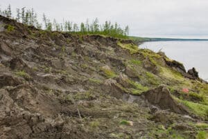
A third of the Arctic’s vast carbon sink now a source of emissions, study reveals
Critical CO2 stores held in permafrost are being released as the landscape changes with global heating, report shows
A third of the Arctic’s tundra, forests and wetlands have become a source of carbon emissions, a new study has found, as global heating ends thousands of years of carbon storage in parts of the frozen north.
For millennia, Arctic land ecosystems have acted as a deep-freeze for the planet’s carbon, holding vast amounts of potential emissions in the permafrost. But ecosystems in the region are increasingly becoming a contributor to global heating as they release more CO2 into the atmosphere with rising temperatures, a new study published in Nature Climate Change concluded.
After millennia as a carbon deep-freezer for the planet, regional hotspots and increasingly frequent wildfires in the northern latitudes have nearly canceled out that critical storage capacity in the permafrost region, according to a new study published in Nature Climate Change.
Read more on Permafrost Pathways.
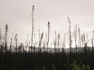
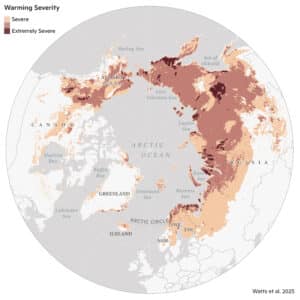
Map reveals Alaskan ‘hotspots’ of extreme warming
Some of the regions changing the fastest due to climate change are in the far north of the U.S. and Canada.
According to a new paper in the journal Geophysical Research Letters, the fastest-changing areas are dotted around Alaska, Canada’s Northwest Territories, and Siberia.
20 of the most vulnerable hot spots were home to permafrost, which is rapidly thawing around the Arctic, with others being boreal forests.a
Ecological warning lights have blinked on across the Arctic over the last 40 years, according to new research, and many of the fastest-changing areas are clustered in Siberia, the Canadian Northwest Territories, and Alaska. The analysis of the rapidly warming Arctic-boreal region, published in Geophysical Research Letters this week, provides a zoomed-in picture of ecosystems experiencing some of the fastest and most extreme climate changes on Earth.
Many of the most climate-stressed areas featured permafrost, or ground that stays frozen year-round, and experienced both severe warming and drying in recent decades.
To identify these “hotspots,” a team of researchers from Woodwell Climate Research Center, the University of Oslo, the University of Montana, the Environmental Systems Research Institute (Esri), and the University of Lleida used more than 30 years of geospatial data and long-term temperature records to assess indicators of ecosystem vulnerability in three categories: temperature, moisture, and vegetation.
Building on assessments like the NOAA Arctic Report Card, the research team went beyond evaluating isolated metrics of change and looked at multiple variables at once to create a more complete, integrated picture of climate and ecosystem changes in the region.
“Climate warming has put a great deal of stress on ecosystems in the high latitudes, but the stress looks very different from place to place and we wanted to quantify those differences,” said Dr. Jennifer Watts, Arctic program director at Woodwell Climate and lead author of the study. “Detecting hotspots at the local and regional level helps us not only to build a more precise picture of how Arctic warming is affecting ecosystems, but to identify places where we really need to focus future monitoring efforts and management resources.”
The team used spatial statistics to detect “neighborhoods,” or regions of particularly high levels of change during the past decade.
“This study is exactly why we have developed these kinds of spatial statistic tools in our technology. We are so proud to be working closely with Woodwell Climate on identifying and publishing these kinds of vulnerability hotspots that require effective and immediate climate adaptation action and long-term policy,” said Dr. Dawn Wright, chief scientist at Esri. “This is essentially what we mean by the ‘Science of Where.’”
The findings paint a complex and concerning picture.
The most substantial land warming between 1997-2020 occurred in the far eastern Siberian tundra and throughout central Siberia. Approximately 99% of the Eurasian tundra region experienced significant warming, compared to 72% of Eurasian boreal forests. While some hotspots in Siberia and the Northwest Territories of Canada grew drier, the researchers detected increased surface water and flooding in parts of North America, including Alaska’s Yukon-Kuskokwim Delta and central Canada. These increases in water on the landscape over time are likely a sign of thawing permafrost.
Among the 20 most vulnerable places the researchers identified, all contained permafrost.
“The Arctic and boreal regions are made up of diverse ecosystems, and this study reveals some of the complex ways they are responding to climate warming,” said Dr. Sue Natali, lead of the Permafrost Pathways project at Woodwell Climate and co-author of the study. “However, permafrost was a common denominator—the most climate-stressed regions all contained permafrost, which is vulnerable to thaw as temperatures rise. That’s a really concerning signal.”
For land managers and other decisionmakers, local and regional hotspot mapping like this can serve as a more useful monitoring tool than region-wide averages. Take, for instance, the example of Covid-19 tracking data: maps of county-by-county wastewater data tend to be more helpful tools to guide decision making than national averages, since rates of disease prevalence and transmission can vary widely among communities at a given moment in time. So, too, with climate trends: local data and trend detection can support management and adaptation approaches that account for unique and shifting conditions on the ground.
The significant changes the team detected in the Siberian boreal forest region should serve as a wakeup call, said Watts. “These forested regions, which have been helping take up and store carbon dioxide, are now showing major climate stresses and increasing risk of fire. We need to work as a global community to protect these important and vulnerable boreal ecosystems, while also reining in fossil fuel emissions.”
Overview of COP29
The 2024 UN Climate Change Conference (COP29) took place from November 11–24, 2024 in Baku, Azerbaijan. The conference was characterized by five key expectations:
- All developing countries expected the adoption of a new global climate finance goal;
- The E.U., United States, and small islands states sought a strong platform to push for higher ambition of emission reductions and to advance the global energy-related targets agreed at COP28;
- The E.U. especially wanted to finish rules for the Paris Agreement offset mechanism (Article 6);
- China, India, Saudi Arabia and other major emerging economies wanted to avoid being pushed towards higher mitigation ambition;
- The African states prioritized a strong outcome on adaptation.
The focus on climate finance permeated the conference, as countries used finance considerations as bargaining chips across all negotiating tracks. The meetings began with an agenda fight as China, India and others sought to discuss unilateral trade measures in reaction to the EU carbon border adjustment mechanism, which they see as an illicit trade barrier. Others sought more ways to reflect climate finance on the agenda. Consequently, one day of negotiations was lost. But delegates were determined to succeed, at least to reduce the disruption expected in 2025 from political upheaval around the world.
Thus, by its second day, the conference settled into a stable mode of work, though countries struggled to advance the negotiations in the first week. The Azerbaijani Presidency had to take much riskier steps to compensate for this. In the second week, pairs of ministers were assigned to lead work on the finance goal, mitigation ambition, adaptation, and Article 6. On Thursday, the Presidency issued a first package of draft outcomes, built on recommendations from technical negotiations and ministers. The presidency organized a meeting, which resulted in most countries criticizing the initial package. But the Presidency published two more iterations, while constantly consulting with all groups of Parties. Through this, a balance was found, and the outcomes were adopted early on Sunday, November 24. Some countries, including India, Nigeria and Bolivia, tried to block the adoption of the finance goal, and were severely unhappy with the outcomes and the process.
Key decisions taken at COP29
The main substantive outcome of COP29 was named the Baku Climate Unity Pact, comprising:
- New global climate finance goal | It calls on “all actors” to raise at least $1.3 trillion per year, and on developed countries to lead the mobilization of at least $300 billion, by 2035. The decision also refers to development finance reform, centrality of public sources, enhanced access, as well as reporting on finance. It launched a “Baku-Belem Roadmap to 1.3T”—a conversation to scale up finance in 2025.
- Mitigation work programme | This decision identified technical options to reduce emissions in cities and encouraged collaboration between governance levels. Parties and observers were invited to propose topics for mitigation dialogues in 2025. A digital platform, to be designed in 2025, will enable exchanging information on mitigation actions.
- Global goal on adaptation | Countries gave instructions to the ongoing work by technical experts on indicators to measure progress towards global resilience. It builds up UNFCCC adaptation work with a permanent agenda item on adaptation, a Baku Adaptation Roadmap, and a high-level dialogue. The purpose and linkages between these various tracks are unclear, except that all should enhance the implementation.
Other key decisions were adopted in relation to:
- Article 6.4 | This decision defined the missing aspects for the Paris Agreement’s mechanism: authorization and registration of emission credits, sharing proceeds for adaptation, and transition of existing forestry activities to this new mechanism. Work on standards, tools, guidelines, baselines, adjustments, additionality should be expedited and be closely informed by technical and scientific expertise through e.g. expert panels.
- Non-market approaches (NMAs) (Article 6.8) | This decision is about the implementation of a work programme on NMAs (such as actions addressing biodiversity and climate, and/or enhancing value systems). Governments concluded the first phase of the work and welcomed a new online platform for NMAs. The next phase will consider ways to overcome barriers to NMAs, to use NMAs to implement NDCs, and to capture them on the new online platform, based on inputs from countries and observers by March 31, 2025.
- Gender and climate change | The decision noted that gender balance has either stayed the same or declined across the UNFCCC and has been inconsistent, but that country delegations have been gender-balanced recently. The decision extends the Lima Work Programme on Gender for 10 years and launches a new gender action plan, inviting proposals for its scope, and encourages Parties to appoint gender focal points, enhance reporting and integrate gender in climate finance. The decision also emphasizes the centrality of gender consideration in UNFCCC operations and the work of the secretariat.
- Research and systematic observation | In this main science-related item of COP29, Parties recognized the new publications by IPCC, WMO, GCOS and other scientific bodies, encouraged the application of revised GCOS monitoring principles, and emphasized the importance of support for enhanced observation systems in developing countries e.g. through SOFF (Systematic Observation Financing Facility).
- Indigenous peoples platform (LCIPP) | A new 2025–2027 workplan for this platform was approved, and the secretariat will explore options for enhancing the participation of Indigenous representatives and for providing interpretation for Indigenous languages. The workplan focuses on convening knowledge holders, regional engagement, and collaboration with UNFCCC workstreams.
There were several key issues that could not be concluded. On all of these, Parties did not reach consensus and will continue next year based on the latest materials discussed at COP29:
- Logistics of the global stocktake | This item was supposed to improve the Paris Agreement’s process to consider the state of the global climate effort every five years.
- GST Dialogue | This item was about how the international community should follow up on the energy-related targets and other efforts identified at COP28. China, India and Saudi Arabia saw this as an effort to pressure them to be more ambitious.
- Just Transition Work Programme | This discussion was about ensuring that ambitious climate action does not lead to unjust consequences for specific groups (or countries).
- Host of COP31 | The group of Western European and other countries was expected to announce the host of COP31. Australia and the Pacific countries offered to host a “Pacific COP” in 2026. However, Türkiye maintained a competing bid, highlighting its geographical centrality, facilities, and the fact that it does not export fossil fuels.
General observations about the outcomes
- The finance goal has several ambiguities, and many developing countries protested its lack of ambition, in particular the $300 billion figure, the invitation to developing countries to contribute finance, the gap between finance needs recognized in the decision and the amounts to be mobilized, and the way it was adopted over opposition.
- The mitigation work programme decision is very limited, but more could not be reached as China, India, Saudi Arabia and others sought to avoid any platforms that could be used to pressure them to more ambition. It does, however, continue the mitigation conversation and there is symbolic value in an agreement on this contentious topic.
- Regarding the non-concluded global stocktake dialogue, developed countries and AOSIS insisted that it should provide a platform to encourage countries to be more ambitious, while developing countries wanted a dialogue focused on strengthening climate finance. However, China, India and Saudi Arabia opposed international conversation on ambition, insisting that under the Paris Agreement, climate targets are nationally determined.
- The decision on adaptation sets potentially unrealistic requirements for the experts working on the global indicators and establishes new workstreams that seem to convolute the adaptation conversations. Symbolism matters here as well, developing countries want major decisions on adaptation at each COP to enhance balance with mitigation.
- With COP29, the design of the Article 6.4 mechanism appears to be complete, and it can start operating. This might be a significant outcome, if the environmental integrity of the mechanism is ensured. Future work will be increasingly guided by its Supervisory Body. Woodwell will seek opportunities to provide scientific expertise to the methodological work and monitor how forestry-related CDM projects are transferred to the new mechanism.
- The NMA agenda put some emphasis on nature-based solutions and will be on Woodwell’s radar, e.g. through opportunities to submit proposals for NMAs to the online platform.
- COP29 also provided much-needed continuity for the UNFCCC work on gender. However, proposals to enhance national reporting of gender-disaggregated data did not advance due to opposition by (in particular) African countries, who cited capacity constraints and conceptual unclarities.
- On science-related negotiations, India, China and Saudi Arabia opposed references to 2024 as being on track to be the warmest year on record, citing that highlighting just one year is scientifically problematic. The same countries also refused to acknowledge that satellite measurements of GHGs could complement national emission inventories.
- Woodwell engaged with the UNFCCC Indigenous platform by hosting LCIPP representatives at the pavilion, providing a good start for future interactions, possibly through workshops and dialogues to be organized by the Brazilian Presidency of COP30.
Outlook towards COP30
COP29 mostly tied up loose ends that have been complicating the UNFCCC for several years: the new climate finance goal and Article 6. However, the dissatisfaction with the finance goal among developing countries might create problems in 2025, it remains to be seen if the Article 6.4 mechanism will have environmental integrity, and no new solutions were found for mitigation ambition. In addition, the global climate policy landscape is now dotted with dialogues and round tables that are supposed to discuss finance, ambition, adaptation, etc., creating a potential distraction from the “ambition homework” that governments should now be undertaking. In 2025, these challenges will be complicated by the intentions of some countries to leave the Paris Agreement.
In 2025, the main milestone is the deadline for new NDCs on February 9. These will show how well the ambition mechanism of the Paris Agreement is working. However, the global climate regime lacks any robust follow-up mechanism for these because, under the Paris Agreement, ambition is nationally determined. The “Troika” of Presidencies of COP28, 29 and 30 will continue its work, but so far has not generated any visible results, and its hands are similarly tied by the paradigm of national determination. Brazil will take a more leading role in 2025 and might benefit from close ties to all major economies and the developing world. In a nutshell, the COP30 Presidency has inherited a major ambition challenge, but has very few tools to respond to it. Positively, Brazil has experienced negotiators and knows how to navigate the UNFCCC.
The official agenda for COP30 was supposed to be modest, but several things not agreed at this COP will need to be taken up again. The issues that should be concluded include: the global resilience indicators, the arrangements for the global stocktake dialogue, as well as just transition. However, the clear expectation is that the COP should do something about mitigation (though nobody knows what exactly), and developing countries, especially those that took home grievances from COP29, will consider the climate finance conversation far from over.
The UN process remains the main framework for coordinating and enabling global climate collaboration. It is slow and it gravitates towards the lowest common denominator, but it continues to bring together the most influential global actors—national governments—to work to bridge their differences.
